 Bagh-e Babur is located on the slopes of Kuh-e Sher Darwaza, southwest of the old city of Kabul. The garden is c. 11.5 ha large and arranged in 15 terraces along a central axis in east west direction. From the top terrace, the visitor has a magnificent vista over the garden and its perimeter wall, across the Kabul River towards the snow covered mountains.
Created by the founder of the Mughal dynasty, Ziihir ad-Din Muhammad Biibur (1483-1530), after his conquest of Kabul in 1504, Bagh-e Babur is one of the earliest surviving Mughal gardens. The king was a passionate gardener and personally designed and supervised at least 10 gardens in his capital Kabul (frontispiece). They are described in the BlJbur-name, but the historical name of Bagh-e Babur is not known. Excavations revealed that Babur did not design his garden on an empty plot: ruins of a monumental building dating to the 3rd century BC and traces of a subsequent occupation to the 15th century made it necessary to clear the ground before a large terraced garden with a different orientation could be landscaped at this very spot. For political reasons, Babur had to move east and conquered northern India in 1526; he died in Agra in 1530. Throughout his years in the flat, dusty plains of India he missed his home country and thus wished to be buried in Kabul. His body was transferred to Bagh-e Babur by his widow around 1544. The texts do not provide a reason why out of all gardens he chose this one. However, remains of older tombs with brick vaults and stone cists excavated underneath the tomb platform revealed that the area was already used as a cemetery, possibly by his Timurid kin -a finding which might provide a context for his choice.
 As the tomb garden of the founder of the Mughal dynasty, Bagh-e Babur became a place of veneration, a symbol, and hence gained superior importance among Babur's gardens: For nearly 150 years, his heirs, especially Jahangir (r. 1605-1627) and Shah Jahan (r. 1627-1658), paid their respects to his burial place and sponsored ambitious building programs to preserve and beautify the garden according to contemporary taste. However, beside the spiritual aspect there was also a political dimension through the representation of imperial presence. While this particular significance fostered the survival of the garden beyond the decline of the Mughal dynasty to the present day, it also exposed the garden to changes of its built surface until the 20th century.
Particularly intrusive was the building program implemented by Amir Abdur Rahman (r. 18801901). He constructed the haramseray in the southeast corner and a pavilion in the central axes on the 9th terrace, and landscaped the terraces and water works. His structural interventions changed the ''face'' and visual concept of the garden significantly: the formerly lofty tomb was enclosed by a wall, the pavilion blocked the view towards Shah Jahan's mosque and Babur's tomb from the entrance in the lower west.
However, Amir Abdur Rahman's garden did not survive for long: King Nadir Shah (r. 19291933) removed these structures apart from the pavilion and haramseray, realigned the tomb terrace on one level and restored its airy appearance, and opened the park with tea houses and restaurants to the general public. He gave the garden a definite "European" touch. It was his garden that was preserved until 2003, while the older ones, and especially the Mughal garden, were unknown apart from standing buildings, such as the tomb and the mosque.
Evidence for these different phases was brought to light in 13 seasons of excavation carried out by German Archaeological Institute between 2002 and 2005, supplemented by information from historical documents, book illustrations, drawings and photographs from the 19th and 20th century. This research placed the cultural history of Bagh-e Babur into social, cultural and political context, deepened the understanding of the site and revealed its position within the tradition of and its contribution to the development of Islamic landscape gardens. It was carried out by the German Archaeological Institute and the National Institute of Archaeology in Afghanistan (DAI, with shared funding from the German Foreign Office and AKTC) within the framework of the Aga Khan Trust for Culture (AKTC) rehabilitation project which started in 2003, in collaboration with the Afghan government, the Kabul Municipality, donors and the local population it included specialists from various fields of expertise, such as architectural conservation, landscape architecture, management, planning, and historic and modern horticulture. Through an appropriate rehabilitation program and a carefully implemented management plan, this outstanding site was restored by AKTC along its historic roots according to international standards and guidelines, and handed over to the Afghan authorities in 2008.
Islamic Gardens: Concepts, Meaning, Function
Bagh-e Babur belongs to the category of Islamic gardens. The Islamic garden subscribes layers of meaning rooted in religious symbolism which set them apart from their European counterparts, despite the fact that conceptual, social and political aspects maybe shared. In order to explain why criterion IV is applicable for the nomination of Bagh-e Babur, it is appropriate to offer some general comments on this type of site and its historical development.
While gardens already in the third millennium BC were integral parts of urban spaces, Islamic gardens follow particular principles in layout and design, function and meaning. Their form derives from an Iranian tradition going back to gardens landscaped by the Achaemenian kings since the 6th century BC, hence they were later coined Persian gardens. With the spread of Islam, this Iranian heritage received new semantic contents linked to symbolism rooted in Islam, leading to and expressed by a canonized layout and design. Under the Abbasid dynasty (8th century AD), this type of garden became an integral part of representational architecture throughout the Islamic world, e.g. at Samarra and Shiraz.
The Persian garden is a landscape garden, designed individually and created intentionally as a space embedded in the aesthetic and spiritual context of its past and contemporary cultural, political and social environment. Hallmarks of these formal gardens are a geometric layout following geometric and visual principles, implemented to nature by water channels and basins which divide the enclosed space into clearly defined quarters, a principle that has become known as chahar bagh (lour gardens), water works with channels, basins, fountains and cascades, pavilions, a prominent central axes with a vista, and a plantation with a variety of carefully chosen trees, herbs. and flowers. The old-Iranian word for such gardens "pari-daiz1i' expresses the notion of an earthly paradise which is inherent to them. As such, they are a metaphor for the divine order and the unification and protection of the faithful through Islam. Perimeter walls are indispensable parts of Islamic gardens: as described in the Holy Koran they guard the entrance and provide protection. Their counterparts on earth fulfill a similar function. These principles are brought to perfection in the gardens of the emperor as the "good gardener".
Notwithstanding a formal standardization, the landscape gardens also reflect diversity and development, bound to function, regional and chronological characteristics as well as technological know how, personal preferences, ambitions and demands. Islamic gardens are multi-functional: they not only serve contemplation and relaxation, but are also a representation and manifestation of power. Designing and implementing a garden demonstrates the occupation of land, holding audiences and celebrating victories or marriages in these gardens signal superiority, or social and political bonds. Starting from the 12th/13th century, tombs for members of the royal family or important personalities were placed into such formal gardens, providing believers a chance to benefit from the spirituality of a venerated person and the particular aura of the garden. It was only during the Mughal period that tomb gardens per se were designed and brought to perfection, exemplified by Homayoun's tomb in Delhi (commissioned 1562 CE) and by the Taj Mahal in Agra (bUilt from 1531 to 1648 CE).
15th century Timurid gardens, which developed from the Persian types, had a great influence on garden design. One aspect greatly promoted the creation of gardens in Central Asia, that is the migrating lifestyle of the Turk tribes, exemplified by the mobile court which pitched tents in encampment gardens, a tradition practiced since long and maintained in the later periods, e.g. along the Great Trunk Road of the Mughals and throughout Iran. These gardens were mobile residences, located outside the urban space, seats of political power and centres of social activities. Although few traces of the early gardens survived, historic descriptions leave no doubt about the magnitude of ambitious projects. The famous gardens in Samarqand and Herat, well known to Babur who was of Timurid descendance, were created by Persian craftsmen who migrated throughout the capitals and workshops in Persia, Central Asia, Afghanistan, and India. The migration of artisans within the network of political alliances and bonds, and shifting centres of political power is a widespread phenomenon during this period, hence, arts and crafts share a large number of technological and stylistic features. Only with the more developed duality of the Mughal Empire which absorbed local Indian features in the east and the Safavid Empire in the west, diverging developments became more distinctive.
We can summarize that Islamic gardens are marked by a canonized catalogue of forms and features, manifest in layout, plantation, and architecture. These are determined by symbolic content (religion, power/status), historical context, and the social and political environment (location, patron, purpose, political stability, financial situation). As such the gardens are not only symbols, but also tools which can be used to mirror and shape social and political relations. Assessing the importance and significance of a historic Islamic landscape garden hence requires to consider these different layers of meaning and the political and social environment within which they were created. Thus, large gardens with a spectacular architecture are not per se the most important sites in terms of historical development and cultural tradition, no matter how important they are as monuments. This implies, vice versa, that more modest sites can be equally or even more important than the former.
Justification of Outstanding Universal Value
Bagh-e Babur is an intentionally designed cultural landscape, according to the definition provided in the operational guidelines § 47. and in Annex 3 §.6: Cultural landscapes are cultural properties and represent the "combined works of nature and of man" designated in Article 1 of the Convention. They are illustrative of the evolution of human society and settlement over time, under the influence of the physical constraints and/or opportunities presented by their natural environment and of successive social, economic and cultural forces, both external and internal.
Criterion IV: as an outstanding example of a cultural landscape which illustrates significant stages in human development.
Bagh-e Babur is an outstanding example of an intentionally designed landscape garden. As a cultural and archaeological site it encompasses the designed landscape and its built architecture, which together form a historic ensemble. It is the only landscape garden in the region which mirrors subsequent developmental stages and reflects shifts in function, style and concept from the early 16th to the early 20th century: from a Timurid pleasure to a Mughal tomb garden, to a 19th century representational garden and a 20th century public park. These phases have left their mark in the garden and depict various stages of historical development and their representation in the cultural heritage.
The original layout and essential architectural elements mirror the idealized form of the chahar bagh plan and are testimony to the spread of Persian and Timurid spiritual and aesthetic concepts towards east around 1500. It is thus the latest surviving pre-Mughal garden designed in the original Persianmmurid tradition east of Iran. Throughout its existence, Bagh-e Babur maintained the main conceptual features of this type of garden, such as the geometric layout with the typical vista, the perimeter wall, terraces, a central axis with water channels and basins, trees, flowers, and, originally, a pavilion.
Bagh-e Babur was designed as a pleasure garden, but became a tomb garden after the death of its founder and, hence, a symbolic place for the Mughal dynasty. It is, therefore, the oldest imperial tomb and the westernmost Mughal garden, and within the borders of Afghanistan the only surviving testimony of a Timurid pleasure garden that was later adorned with Mughal architecture. The garden was adorned with decorative schemes developed in India during the Mughal Period, particularly under Shah Jahan. Features added to the garden until 1660 include a marble platform with lattice work around the tomb, a headstone, a mosque, a perimeter wall, a gateway, a caravanserai, water pools with fountains on each terrace, and marble lined water channels. They witness of the transformation of a Timurid to a Mughal garden. Located far from the capitals in Pakistan and India, the embellishment of Baghe Babur emphasizes its symbolic and, for a certain period, political significance. Although it lost much of its importance with the decline of Mughal power after Shah Jahan, one of his descendants was buried close to him in the 18th century.
After a period of decay from the late 17th to the late 19th century, the garden was important enough to be restored 200 years later by the rulers of a modern Afghanistan; it mirrors the beginning of a new era. After 1880, Bagh-e Babur was re-designed by Amir Abdur Rahman, ruler over an united Afghanistan and passionate builder. Changes include landscaping, buildings, vista, and waterworks. The buildings and landscape works commissioned him thoroughly changed the appearance of the upper terraces, they are a portrait of the architectural language typical for this ruler. The garden was used as an international guesthouse and thus retained a representational character.
In the 2th quarter of the 20th century, Nadir Shah once more redesigned the garden in terms of landscaping and built architecture. He distanced himself from his predecessor, but although the more airy layout of the garden was closer to its original scheme than under Amir Abdur Rahman, Nadir Shah rather followed European design schemes; this is also reflected by the fact that it became a public park.
Thus, as in intentionally created Islamic garden, Bagh-e Babur is an outstanding example of a cultural landscape since it is, on one hand, a unique testimony for a specific cultural tradition, its spread and metamorphoses, while it reflects, on the other hand, changing aesthetic concepts. Thus, within one cultural ensemble different stages of human and cultural development are preserved and embedded into its original scheme.
Satements of authenticity and/or integrity
As outlined above, Bagh-e Babur reflects four main periods of use over 500 years: the late Timurid tradition, the Mughal tradtion, with at least three building phases (Babur, Jahangir, and Shah Jahan), the late 19th century (Amir Abdur Rahman), and the early 20th century (Nadir Shah).
The changes imposed upon the gardens' appearance during the later two periods, in the late 19th and early 20th centuries, are related to structure, built architecture, and, in cases, to the visual concept. The central axis as an important scheme of the layout was maintained. These different '1aces" of the garden reflect not only changes in taste and technology, but also in function -aspects which are directly related to how the rulers want to present themselves. These later phases also have their imminent historical value. However, since Nadir Shah removed most of Amir Abdur Rahman's structures that had a negative impact upon the original scheme, in particular the vista and airy atmosphere of the tomb platform, the decision of AKTC and its Afghan counterparts to restore the 16th century Mughal garden while preserving and partly restoring the surviving buildings of Amir Abdur Rahman and of Nadir Shah was a logical step, coherent with the need for authenticity on one hand and integrity on the other. The rehabilitation project was based on the most detailed information ever collected in a landscape garden. Its history came to light during 13 seasons of carefully documented archaeological excavation which unearthed cultural remains from the 3rd century BC onwards, and which was complemented by the study of historical documents as well as drawings and photographs from the 19th and 20th century. Further evidence was gathered from miniature paintings which illustrate gardens from various periods, and through comparative studies. The interpretation of the data and the reconstruction of the garden benefited from the canonized formal repertoire of Persian gardens.
Landscape and water works:
The landscape, predominantly defined through the terraces and the central axes, still represents the original layout. The height and width of the terrace was determined during the excavations through the discovery of the Mughal irrigation system, traces of the water basins and channels in the central axis and on the lateral fields. 19'h and 20'h century modifications were recorded and removed (partly already during the 20th century). The reconstruction of the central axis with a marble-lined water channel, cascades and basins with fountains is based upon the archaeological findings, although slight modifications of the width of the water channel were required in order to control the water flow.
Plants:
There are a number of records for the study of horticulture in Persian, Timurid, and Mughal gardens, mostly contemporary written documents and miniature paintings. In case of Bagh-e Babur, this is primarily the autobiography of the king, in which he explicitly names the plants, books on botany, and miniature paintings. Paleo-botanic studies were not conducted since they would not provide reliable results: the layers of use and irrigation are thin, disturbed by later installations, and thus liable to inclusions of recent pollen. It can be assumed that the original garden with a mixture of fruit and other trees and bushes, herbs, and flowers, soon became more formal. Certainly, the "European" garden of Nadir Shah showed a very different plantation profile than the original garden. For this reason, all efforts were made to stick to indigenous plants for the replantation program which was implemented by AKTC.
Buildings:
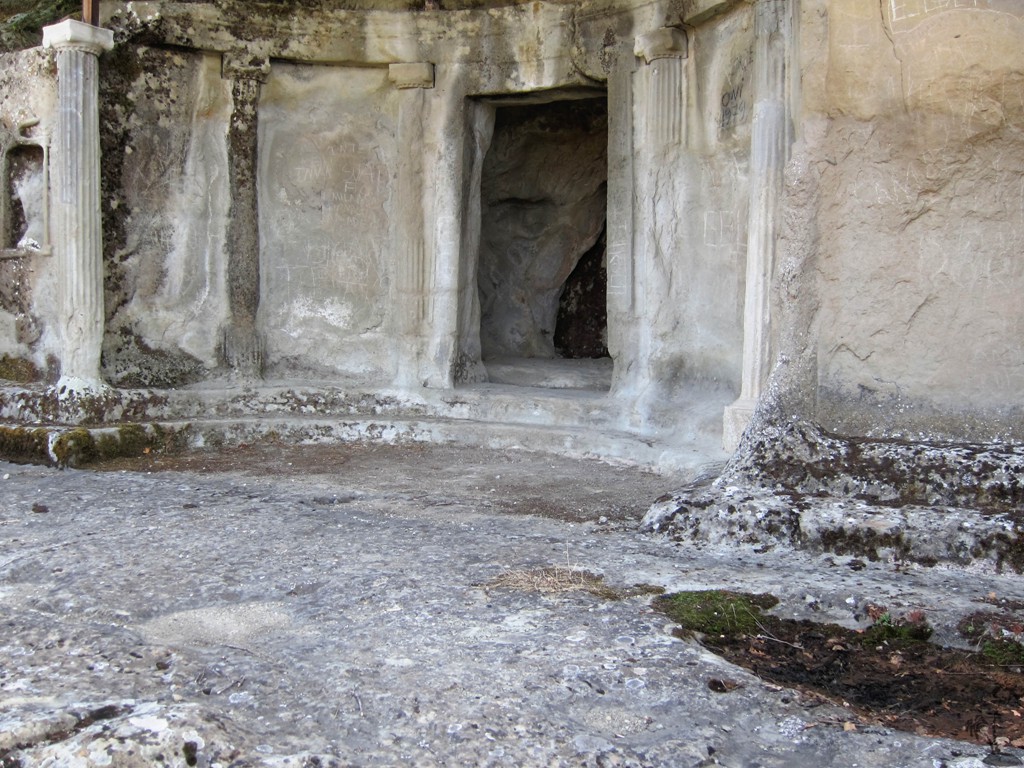
The most ancient buildings in the garden, excluding structures which pre-date the garden, date to the time of Babur himself. They are confined, however, to his tomb and small parts of the irrigation system uncovered during the excavations near and under the mosque. According to his autobiography, Babur wanted to be buried in a simple earthen tomb and we have to assume that his widow obliged to this wish. His successors, especially Jahangir, ruler over a consolidated Mughal empire, felt obliged to adorn the resting place of their forefather during their pilgrimages and visits to Kabul. Jahangir describes his building programs in the garden in his memoirs: among others a platform and marble jali around the tomb, a headstone and a perimeter wall for the garden. The most tangible mark on the garden was left by Shah Jahan. He built the mosque and re-installed the irrigation systems and water works. According to his memoirs, he also built a gateway on the western, lowermost terrace, where the visitors enter the garden and looked towards the mosque and tomb along the central axis and the water channel.
Shah Jahan·s garden survived, although in ruins, until the 19'h century when Amir Abdur Rahman thoroughly changed the landscaping through the addition of buildings and a new water system. Most intrusive were the haramseray in the southeast and the pavilion, probably built on top of a destroyed Mughal pavilion or platform in the central axis, an enclosure wall around the tomb with a staircase towards the mosque and a chain of buildings with cupolas along the western edge of the tomb terrace, which segregate the mosque and particularly the tomb from the lower terraces -and from the view.
Most of his smaller buildings were turned down already in the early 20'h century by Nadir Shah, who restored the airy character of the upper terraces. The only buildings which survived are the pavilion and the haramseray, although in ruins. They have their own cultural and historical value and have been restored.
During the second half of the 20'h century, a public swimming pool, a greenhouse and maintenance buildings were added to the garden. In the frame of the rehabilitation program, AKTC relocated them to more convenient locations.
With reference to particular features we can summarize:
The layout of the garden and the water works with channels, basins and cascades represent the original scheme.
The tomb terrace: various phases of modifications took place. The marble platform (17 x 17 m) with a jali screen mentioned by Jahangir is attested through excavations and finds, and visible on a photograph taken in 1879 by Burke. A marble enclosure around the tomb has been reconstructed based on the evidence from an image dated to 1838 (Masson) and marbles scattered through the garden. The buildings constructed under Amir Abdur Rahman were removed by Nadir Shah, but are known from photographs and were exposed during the excavations. The enclosure wall built by him around the tomb platform has been reconstructed. In the frame of the rehabilitation project, the level of the tomb terrace was readjusted to its previous landscape and the shelter constructed by Nadir Shah to protect the tomb was removed.
Shah Jahans mosque, built in the 12th year of his reign (1638 CE), was disassembled and restored in the mid-20th century, but was rebuilt to a large extent with original marbles. It underwent restoration and conservation in the frame of the AKTC project. Its present appearance corresponds to the original one.
Shah Jahan's gateway: this building is described in his memoirs as a building with a golden cupola, located at the entrance on the lowermost western terrace. Demolished and overbuilt probably in the 19'h century, traces of this gateway came to light in 2004. Subsequent excavations unearthed the foundations of this building and facilitated its graphic reconstruction. Its foundations are preserved and incorporated in the present entrance area. Around them a visitor centre has been built on the footprint of a pre-gateway caravanseray.
The perimeter wall of the garden was probably first built, or rebuilt, by Jahangir. Made of mud (paksha), it was destroyed and rebuilt several times. Although its particular date is not known, the recent restoration maintains the outline and shape as indicated by surviving older portions. Close counterparts are found in Mughal miniature paintings.
The rehabilitation of the garden has restored the appearance of the Mughal garden from the times of Jahangir and Shah Jahan, while preserving important later additions, in particular the pavilion and haramseray built by Amir Abdur Rahman.
Integrity
As described above, main features of an Islamic garden -and thus measures of its integrity are the geometric layout, the vista, the architecture, and the plantation.
Despite the damage inflicted upon the structures after the late 17th century and the resulting changes of some aspects, the integrity of the cultural landscape -as a testimony of its time from the 16th to the 20th century -is preserved. A major feature is the visual connection of the upper and the lower portion along the central axes -in both directions. The rehabilitation program has restored and preserved this concept.
The removal of buildings dating to the last five decades, such as the swimming pool and maintenance buildings, has much improved the integrity and restored the original character of the garden.
The rapid growth of the vegetation, comprising of historically attested plants, contributes to this appearance, consolidates the soil and thus prevents erosion, and serves as an air filter.
The water supply system as a conditio sine qua non for the functioning of the garden has been improved and secured through the multiplication of sources and modern technological equipment (as well as through social works with the local community, who benefits from the water supply).
Although there have not been major intrusions by new construction in the immediate environment of the garden, which is protected by the MoU signed between the Afghan Government and AKTC, it is vital that any effort is made to maintain the present low-rise character out of respect for the vista, for example through the implementation of a wider buffer zone.
Administrative measures have been taken by the Government of Afghanistan, Kabul Municipality and Aga Akhan Development Network (here after called AKDN) to ensure the success of this program. With the completion of the bulk of the physical rehabilitation and conservation works, the Kabul Municipality, the Ministry of Information & Culture and AKDN have signed a Memorandum of Understanding (MoU) in 2008 in which it is agreed that Bagh-e Babur should retain its status as an indivisible green space and historic monument in its entirety (Zones 1 to 6), within which the provisions of the 2004 Law on the Preservation of Historical and Cultural Heritage shall apply, and be taken into account in its operation as a public recreational facility within parameters laid down in this document. This law states inter alia that "any modification of the structure of a registered monument of historic value is prohibited..."
The MoU states, that "Baghe Babur should retain its status as an indivisible green space and historic monument in its entirety (Zones 1 to 6), within which the provisions of the 2004 Law on the Preservation of Historical and Cultural Heritage shall apply, and be taken into account in its operation as a public recreational facility within parameters laid down in this document. ". It is therefore clear that the term "Bagh-e Babur", as an indication for the protected area, refers not only to the area enclosed by the perimeter wall plus the new public swimming pool, but includes five further zones (of nearly 11,000 m2) outside the perimeter wall.
The MoU also regulates the management of the site. The Bagh-e Babur Trust (BBT) has been registered as a non-governmental organization with the Ministry of the Economy in Kabul. The goal of the independent, not-for-profit entity is "to safeguard and ensure effective operation and management of the garden and the surrounding area to appropriate international standards, and in accordance with the relevant laws of the Islamic State of Afghanistan". The Board of the Bagh-e Babur Trust' (The Board) "consists of representatives from Kabul Municipality, the Ministry of Culture & Youth and AKDN as further described in section B 2(a) herein, who shall provide strategic and policy oversight for the management of Bagh-e Babur, by meeting on a regular basis in Kabul". Apart from oversight and control of the annual budget and business plan, the Board endorses proposed operational policies and appraises the performance of the Garden Management Team.
The Garden Management Team (GMT) is responsible for the management and operation of the garden under provisions of the MoU. With guidance provided by the Board, the routine management of the garden as a public facility is the responsibility of the GMT, operating under the overall supervision of a Garden Manager who has the responsibility for day-to-day visitor management, operations, financial control and maintenance.
The GMT operates under operational guidelines which govern obligations and requirements related to cleanliness, safety and privacy, but also rule and regulate events to take place in the garden, buildings, activities in- AND outside the perimeter wall, maintenance, and ensures integrity and authenticity (horticulture, lighting).
With the completion of the rehabilitation in 2006 and the implementation of the institutional management plan within the framework of the MoU in 2008, Bagh-e Babur is the only carefully managed public space in Kabul that offers recreational facilities to the citizens. In 2008, 300.000 people visited the garden and this number will be higher in 2009. In addition, several cultural events are organized in the premises. These numbers have to be maintained. They make amply clear that 1. the garden is a highly integral part of the cultural and social life and 2. that the demand for such a facility is immense. The success of the garden as a public space is dependant on a management that secures -apart from the necessary maintenance of the plants and buildings -cleanliness, safety and privacy.
Comparison with other similar properties
Bagh-e Babur can be compared with older Persian and Timurid gardens on one hand, and with later Mughal gardens on the other. Of the former, only a few traces are preserved, knowledge mostly comes from written sources and miniature paintings. Likewise, none of the other early gardens is well preserved, and most gardens in Iran date to the later 16'h century (e.g. Bagh-e Fin and the gardens in Isfahan).
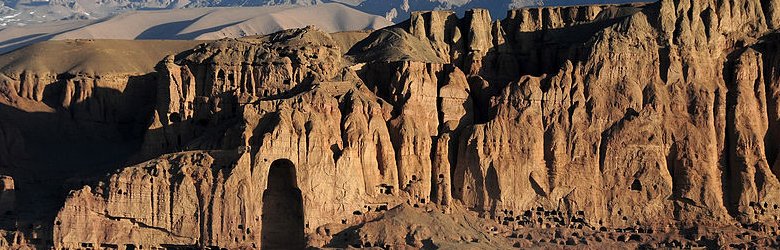
Likewise, few traces of the Timurid gardens in Samarqand and Herat survived. However, historic descriptions leave no doubt about the magnitude of these ambitious projects. Ak Saray in Shakhrisabz, Uzbekistan, is a monumental complex founded by Timur as one of 33 landscape sites in the late 14'h century (1379-1396) near Samarqand. Like Bagh-e Bihisht (1378), it combines a series of older gardens into a new form. Several examples existed at Herat, Timurid capital for almost 100 years, but they are all lost. Compared with allegedly 71 ha large gardens in Samarqand, Bagh-e Babur is of modest dimension, reflecting the fact that the king was still rather poor and just had gained power, after being expelled from Samarqand and his home country in Ferghana -his empire was yet to be built. The earliest known gardens in India date to the 13th/14'h century, but they still lack a standardized layout (see e.g. the Tuqluq garden at Vasant-Vihar, Delhi). Landscape gardens took a considerable surge only under Babur, who also "imported" the chahar bagh to India. The closest chronological comparisons are Baburs Lotus and Bagh-e Nilofer gardens in Dholpur and the Moonlight garden and Ram Bagh in Agra. Yet, in layout and landscaping Bagh-e Babur is more akin to later Mughal gardens in Kashmir (Shalimar, Achabal, Nishat Bagh. PI. 11-12). There, the mountainous landscape is better suited to a terraced layout than the Indian plains with their slowly flowing rivers. Homayoun's tomb in Delhi, commissioned in 1562 CE by his son Akbar) and the Taj Mahal in Agra (built by Shah Jahan between 1631 and 1648 for his wife Mumtaz Mahal) are gardens of a different scale: they are designed tomb gardens and represent the highest conceptual standards of their patrons in order to fulfil their purpose, namely to adequately commemorate the status and dignity of the deceased person, and the splendor of the Mughal empire. Enrolling Bagh-e Babur in the Tentative List contributes to the survival of the only preserved landscape garden designed in the original Persian and Timurid tradition, which later became a Mughal tomb garden.

 Kotila Mura located on a compressed hillock. about 5 km. northern of Salban Vihara in the Comilla Cantonment place is stunning Buddhist organization. Here three stupas are discovered part by part comprising the Buddhist "Trinity" or three jewelry i.e. the Buddha, Dharma and Sangha.
 In its greatest components, the variety is about 4.5 km across and its maximum mountains obtain a size of about 45 meters. These highlands were once heavily forest with an large quantity of outrageous lifestyle, but contemporary improvements have rudely disrupted its peaceful and heavenly establishing.
 At kutila mura, the best pile in the east aspect of the variety near ananda vihara, were found the most eye-catching typical monuments in Mainamati The excavated typical monuments involve three key stupas and a variety of additional chapels and chaitya-halls designed around them, all of which were encased by a large edge wall. Exciting and complex architectural types and eye-catching designs have been safeguarded at the website. Excavations have not yet been accomplished here; the monastery in the south end and two huge stupas in two pizza of the website stay to be removed yet. The excavated proof indicates 7th millennium AD as the date of the beginning of these typical monuments. The website stayed filled until the Thirteenth millennium AD as indicated by an Abbasid money retrieved from an in the of the website.
 The Kotbari Mound revealed clear records of a Shalvan Vihara type monastery with a cruciform shrine in the hub. A huge mosque and its connected graveyard have taken over the website.
 The comprehensive great pile on the european side of the variety, about 2.5 km to the north west of the most southern website of Chandi Mura, in the area known as Rupban Mura, had noticeable architectural continues to be in the shape of a round dome at the top of the pile. Treatment of stones by regional population has already triggered devastation of the revealed architectural continues to be. The website has the potential of producing essential continues to be.


